Saturday, April 29, 2006

Just one Trolley Lane Cab Driver Scofflaw Friday

This was arount 7:00 pm.


In the morning it was all clear except for one delivery truck, which I didn't bother to photograph.

Thursday, April 27, 2006

Bike Lane or Parking Lot

Today the trolley lane was a parking lot in the morning as well as the afternoon.

This morning, at around 7:20, there were two landscaping trucks completely blocking the trolley lane between the aquarium and the world trade center. The third picture shows the boss man (the guy growing a tumor on his lower lip) and his herd of Mexicans.


The boss man said he was hired by the National Aquarium, and the Aquarium told him to park in the trolley lane. I told him what makes him think the Aquarium has the authority to block a public right-of-way? He was actually very polite, and he said he understood my frustration and he would no longer park there. There is plenty of room for the landscaping trucks in the pulloff on Pier 4.

Just a short ways down in front of the Pratt Street Pavillion is this guy. Note in the second picture, there is plenty of room for him to pull off into the area for unloading trucks. But he has chosen not to do so. I asked him why, and he said if you pull in there you can get blocked in. So instead, he blocks everyone else.


Around the corner on Light Street, right before the pedestrian bridge, is another food service truck. He wasn't unloading, he was just parked there. He has to go past a big "DO NOT ENTER" sign to get where he was. When he saw me taking pictures, he backed out and left.


Now for this evening. The return of the tour buses. This is just after 7:00, in front of the ESPN Zone. He pulled out when he saw me taking pictures.


There was only one cab driver today.


And one idiot woman, who decides to block the trolley lane even though she could go 10 feet ahead into a pull-off area.

Wednesday, April 26, 2006

Letter to 2KSports about their ad bus illegally parked in the bike lane

I just posted the following on the 2KSports 2K6 Major League Baseball forum, at http://www.2ksports.com/forums/showthread.php?p=716493#post716493

-----------------------------------------------------------------------------------------

I commute on my bike through the middle of Baltimore every day. There is one safe and legal route through downtown.

Today, there was a tour bus pulling a trailer parked in the middle of the bike route completely blocking it. Here is a posting on my blog, with pictures: http://thevcblog.blogspot.com/2006/04/bike-lane-or-2ksports-billboard.html

As you can see in the pictures, the tour bus is parked in front of a "NO STOPPING" sign, and the bus is wrapped with a giant advertisement for 2K6 Major League Baseball. And the bus completely blocks the way for cyclists such as myself.

The bus was parked in front of the ESPNZone Baltimore on Pratt Street in the Inner Harbor. It appears that 2KSports is attempting to advertise their video game with this bus.

I find this obnoxious. Just because you want to promote your product doesn't mean you can park illegally and deny everyone else use of the public right-of-way.

This letter will be posted to my blog as well, and sent to the bikehon e-mail list, which is a list for Baltimore bicycle activists.

Any response from 2KSports explaining themselves will also be posted to my blog.

DrewInBalto.

Bike Lane or 2KSports Billboard

Today there was only one cab parked in the bike lane. The driver was ashamed of himself.


But the real problem was the giant tour bus pulling a trailer completely blocking the way.


It appears the illegally parked tour bus is situated in the bike lane so all the customers of the ESPNZone can be made aware of 2K6 Major League Baseball.

Tuesday, April 25, 2006

Bike Lane or Parking Lot

It was pretty much gridlock on the trolley lane today.

First there was this guy illegally parked in front of the Pratt St. Pavillion. The first picture shows the guy getting into the car. He appeared to be fishing his dinner out of the dumpster by the Cheesecake Factory. He's driving away in the second to escape my camera.


Next there was this cab by the ESPN Zone, who fled when I whipped out the camera.


Right in front of the cab was this car, which was parked with no driver, but a passenger who was pretending I wasn't there.


And last, we have this asshat in his Lexus, who decided to park and talk on his cell phone, even though there was a pulloff just 10 feet ahead.

Monday, April 24, 2006

Today's Scofflaw Cab Driver


This disgrace to honest cab drivers everywhere is illegally parked in a NO STOPPING zone in the trolley lane in front of the ESPNZone. This is just before 7:00 pm. He took off after I took his picture.

Sunday, April 23, 2006

Bike Ride Report - Virginia 200k Brevet

Yesterday was the DC Randonneurs Virginia 200k Brevet. Here I am at the end in the pouring rain soaked to the skin.


I drove out the night before and slept in Debra's Element. It was quite cozy and I got a good night's sleep. I like to sleep in the car in the rain.


Another thing that is nice about the Element is it's easy to change out of your soggy, foul riding clothes and dry off and put on nice clean clothes out of the pouring rain. Unfortunately, I forgot and left the plastic bag of stinky bike clothes in the Big OE last night, and Debra's car is pretty odiferous today. I am in the dog house. Since Debra is pregnant, she has become hypersensitive to bad smells. I am in the dog house.

Here are all the brevet riders about to take off from the starting line in the drizzle.


Eventually the drizzle turned into steady rain, but after about three hours it stopped. Most of the ride was very nice.

The first control was at Yoder's Country Market in Pratts, VA. This place is fantastic. They have incredible sandwiches. This is a Mennonite place, or some similar deal where they all dress like Little House on the Prairie.


Anyway, all the food is incredibly wholesome, and it appears to be locally produced. Maybe not the Gatorade, but most of it looks that way.

Behind the store, they have some pens containing future sandwiches.


There are chickens, and ducks, and pheasants, and Guinea fowl.

There are also goats.


I took this picture especially for Debra as part of my campaign for us to move to the county so I can sit on the porch and play the banjo. I was making good headway with this picture ("Is that a BABY GOAT? It's soo cuuute.") But then I pushed my luck.

The next control was at the Syria Mercantile Company, which is in Syria, VA. This is the last stop before the big, steep climb to Etlan.


This is also the first restroom in quite awhile. The restroom is across the street in a big white barn.


It's dark and scary inside. You have to wander way in the back past the spiders and snakes and the Blair Witch to find the restroom. It smells like decaying apples.


The gourds drying from the ceiling are pretty cool, though.

This is what the scenery is like after the climb on Etlan Rd. It's pretty strenuous. You have to use the small ring a lot.


I took this picture to share the view with the other brevet riders, because they probably didn't get to see it. That's because I was supposed to turn a half-mile back. One thing that makes the picture nice is because the view is from the top of a big hill.

I had a big dilemma on where to make the last rest stop. There was a store with a fresh spring somewhere about 20 miles out. I figured I'd stop there, fill up my water in the spring, eat my last banana, and I'd be all set.

Crista and Chuck had a secret control set up at mile 100. They said it was the last control. I looked at the cue sheet, and it sure was. "But where is the control with the spring?" Crista said it wasn't a control, and it was at Laurel Mills, five miles back. I decided to push on to the next store, at Orlean, which was 13 miles away and only 10 miles from the end. Crista asked if I needed any water. I said I was OK. I set out.

As soon as I took the next pull on the water tube, I discovered I was out. Even though I was thirsty and hungry, I was still thinking about riding straight to the end, which was only 10 more miles, even though there were a couple climbs and one of them was really steep. But I stopped, and had a Gatorade and my banana. What's the hurry?

If only. As soon as I got to the big hill, the sky opened. It poured hard the last four miles. I was pretty sure it was just a sprinkle, so I didn't stop to put on my rain jacket. After a very short while, the jacked wouldn't have made any difference. So I rode the rest of the way in and got soaked. If only I had pressed on. I probably would have beat the rain.

Here's the map with the actual GPS track.

You can also look at the track on MotionBased.

Monday, April 17, 2006

Bike Ride Report - Fleche

Saturday and Sunday, I rode a Fleche. 230 miles. 24 hours. Dewey Beach, DE to College Park, MD.


A Fleche is a Randonneur event traditionally held on Easter. You make a team and ride a point-to-point route. All the teams for your club meet at a common destination at the end, where everyone collapses and falls asleep. The rules say the route has to be at least 224 miles, and the last 25 km have to be in the last two hours.

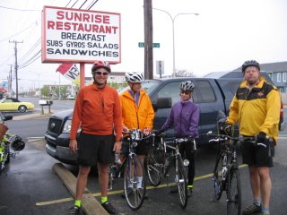
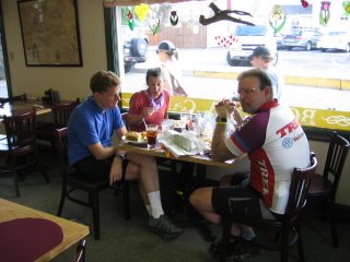
Here is my intrepid team, which is named "Team Torque". That's me, Bill, Lynn, and Jim, from left to right, as we are about to set off at 8:00 am, after a hearty breakfast at the Sunrise Restaurant, in Dewey Beach.


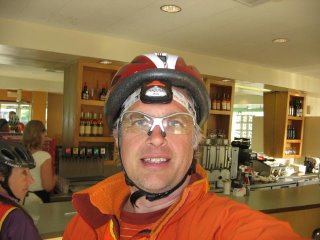
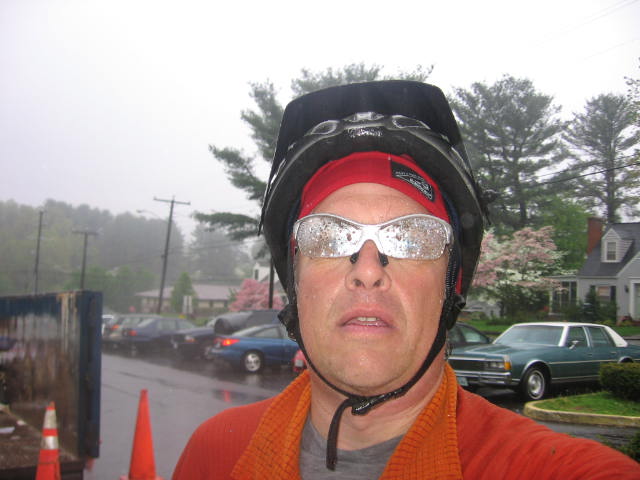
Note how I am wearing a cheap red bike helmet, instead of my usual fancy silver one with abundant ventilation holes and aerodynamic sculpting. That's because I left my bike helmet at home. I had to procure a new one the night before from Wal-Mart. It is very frustrating shopping at Wal-Mart. Wal-Mart is supposed to excel above all other retailers at knowing what their customers want. So I go into Wal-Mart, and in the bike helmet section is a bike helmet with NEON ORANGE FLAMES across the front! RAT FINK! BIG DADDY! YEAH BUDDY! I was so excited!

Well, not so fast. The flames across the front helmets are only available in children's size, years 14 and under. I tried to jam it on my head, but it was just no use. My head is just too fat. Stupid Wal-Mart. If Sam was still alive, there would be helmets with neon flames across the front for everyone. At least the boring helmet I wound up buying only cost $17. It has a helpful sticker inside with a big arrow on it saying "This is the front." I suppose Wal-Mart does still know a little about their customers.

Back to the bike ride. When we set out, there was a headwind, and it started to rain. The rain stopped after an hour or so, and then it cleared up for the rest of the ride. However, the headwind persisted for the next 120 miles, and it blows hard on the Eastern Shore, whcih is flat and often treeless.

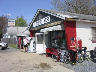
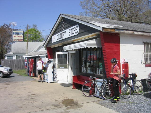
Our first control was Nascar Al's, a country store east of Greenville, DE. The sky is clear and the wind is blowing.


Headwinds are not so bad for me on my recumbent. They took a toll on the rest of Team Torque. Here is a picture from Sudlersville, MD, where they have a monument to Baseball Hall-of-Famer Jimmie Foxx in the town park. I was waiting here for the rest of them to catch up. Jim was back there somewhere fixing a flat tire.


This was about mile 70. Despite the headwinds, we had a 45 minute cusion at that point, but it was down to a 10 minute cushion by the time all repairs were complete and all hydrations were consumed at the Citgo a block over.

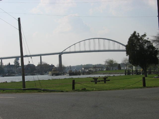
This is the bridge over the Chesapeake and Delaware Canal, in Chesapeake City, MD. Yes, we have to ride over this narrow bridge with no shoulder and flimsy looking guardrail that is very, very high above the water, even though one might think a charming small town like Chesapeake City would have a picturesque low bridge.


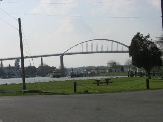
We had dinner at the Bohemia Cafe, which was yummy. Here is Team Torque gathering our Iron Will and Nerves of Steel to face the bridge.


As it turns out, the bridge had no traffic to speak of and was just fine. And we had a lot of fun sharing scary bridge stories. It seems both Lynn and I have ridden into Charleston, SC from the north on US 17, which is about as bad as a bridge can be on a bike.

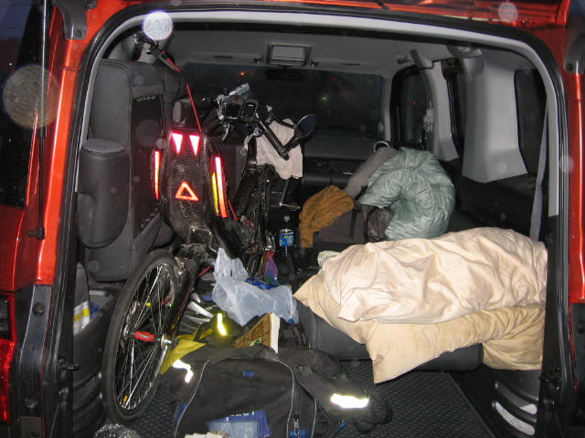
Soon after this it got dark, and so I stopped taking pictures. Right after Elkton, it gets hilly, and it's pretty strenuous. We had a control in Quarryville, PA, at the Turkey Hill Dairy Store, which was a big hangout for rednecks in pickup trucks.

We rode through Harford County on MD 165, which has a smooth, wide shoulder, and was very smooth going. We stopped for a break in Jarrettsville. I think this was about 2:00 am. This part of the ride is pretty foggy. We realized that we were going to be very hard pressed to make it all the way to Arlington on time. The headwinds and hills in Pennsylvania had taken a toll.

Luckily, Lynn knows all the rules, and she explained that as long as we rode the required 224 miles and had a 22 hour control more than 25 km from the end we would succeed. Our planned route was 240 miles, so it would be possible for us to move the control up to some place past 209 miles, and then ride 16 miles to the first available convenience store. What a lifesaver. We decided to move the 22 hour control from the 7-11 in Calverton, MD to the 7-11 in Annapolis Junction, MD. Our cushion went from -20 minutes to 40 minutes.

After this, we went into Baltimore via Glen Arm and Perring Parkway, which is by far the easiest way into the city from the northeast, in my opinion. It's very scenic too, and a shame we did it at night.

While Jim and I both live in Baltimore, and can deal with inner city neighborhoods, Lynn and Bill had expressed some concern. If you go Hillen Road to Harford to St. Lo Drive to Wolfe St, you are going downhill through all the bad areas. Unless you have some kind of mechanical problem, like when Lynn's headlight bulb burned out at the intersection of Hillen Rd and Harford Rd at 3:00 am on Saturday, and we spent 15 minutes getting it fixed. (She wound up borrowing one of Bill's. Go team.) I didn't think it was an appropriate time for me to explain that the corner of Harford and the Alameda a block down was one of Baltimore's most notorious drug corners, and the big flashing blue light on the phone pole marks the location of a police surveillance camera.

The camera seems to be doing the job. The corner was deserted.

We rode through Fells Point and Little Italy, and stopped for a break at the 7-11 on Light St. in Federal Hill, as deranged homeless madmen pounded on the street signs at the corner of Cross St. By the time everyone was finished with their coffee (Lynn), goo (me) and Cheddarwurst (Jim), we had no more cushion, and I told everyone no more messing around, we have to put the hammer down to get to the 22 hour control by 6:00, and it's not flat either.

Team Torque came through. We hammered up the hills on Annapolis Rd in Westport, and pounded through the nasty littly steep rollers on River Rd. We zipped along the two mile flat stretch of Race Road, and clawed our way out of the Patapsco Drainage Basin between 100 and 175. We plunged past the prisons on Brock Bridge Road to arrive at our 7-11 with 10 minutes to spare. (Jim, amazed, noted we just did 18 miles in 1:45. There is 1200 feet of climb. It's my commute.)

This was mile 213 on my GPS. We had a strategy session to figure out the easiest way to knock off the last 17 miles. We were all pretty spent. Lynn was monosyllabic. Gratuitous hills were out of the question. We decided to do Brock Bridge to Montpelier to Cedarbrook and then Odell Rd. to Edmonson to Sunnyside to Rhode Island Ave. If we could make it to the top of Cedarbrook, it's pretty much all descent from there into the Anacostia watershed.

Which is what we did. We were coasting down Rhode Island Ave, with plenty of time to spare. Where Rhode Island ends in Berwyn Heights, we were still a mile short. We cut over on Paint Branch Parkway to Route 1, and headed south looking for the final control. And there it was, just south of the University of Maryland campus, and right in front of a big hill, the gleaming glass brick and polished metal nirvana, the end of the road, Plato's Diner. With a sausage and cheese omelet for Bill and a big piece of pie for me.

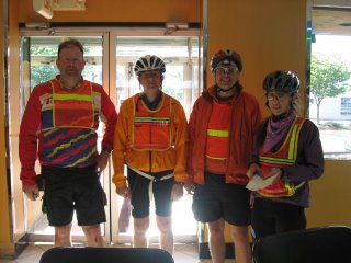
Here we are, after conquering the Fleche.


Lynn totally saved our butts. If she hadn't explained how we could adjust the 22 hour control, we would have rolled into Arlington 30 minutes late with 16 unneeded miles.

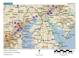
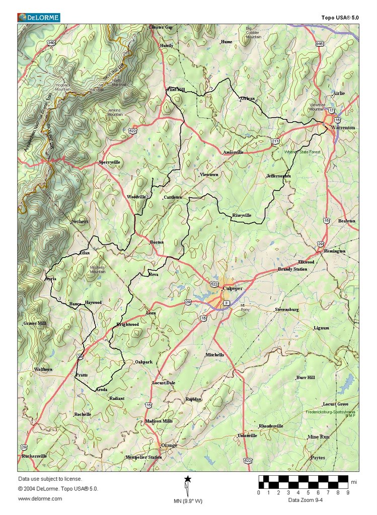
Here's the map, with the GPS track for the route as ridden.

I've also uploaded the recorded GPS information to MotionBased, the link is here. You may need to register, I haven't tried linking to them before.